Introduction:
As a continuation of our land navigation series, this week
we will be completing the course using only our GPS units. This brought a
challenge to the task because we could no longer use our maps. The main purpose
of our activity was to determine how efficient we could be using GPS as our
sole navigation, that is, how does having only one tool change the landscape of
the event. (one tool is good, two tools is better, three tools is great….)
For this exercise we worked in the same groups as the
compass navigation, but this time we worked on a new orienteering course. (Last
week we worked on course 3, and course 1 this week.)
We each had our own eTrex GPS unit, with a list of UTM
coordinates for each point we had to get to. We were then able to navigate to
the list of points based on matching our UTM coordinates to the ones given to
us.
Methods:
The first thing we did was to start our track logs on the
Garmin eTrex unit. The track logs will be used in the lab to determine just how
efficiently we travel between the points. Track log took a reading every X
amount of time (for my log I believe it was every 30 seconds or every minute)
so then we have a series of points to follow our path.
We then were given the list of points and the UTM
coordinates by our professor. There is a function in the GPS where you can type
in the UTM coordinates and the GPS will guide you there, however that would
defeat the purpose of the exercise so we didn’t use it. We instead, had to
watch the UTM coordinates change as we moved around, then we could get a good
bearing of what direction increased and decreased out X and Y coordinates. Once
we figured that out, we could navigate somewhat efficiently from point to
point.
At the beginning it took a little while to figure out the
exact directions. But once we were able to figure out how the cardinal
directions played into the UTM directions we were able to navigate to our
points rather efficiently. We completed the full 5 point course in just under 3
hours.
When we returned to the lab, it was time to import out data
into the GIS. We first had to import the tracklog from the GPS unit to the GIS.
To do this, we used the DNR-GPS software loaded on the computer. This gave us a
list of points, and together these paths made up our path that we took through
the course. After this was imported we added the shapfile to our Priory
geodatabse. We also all sent out shapefiles (converted into feature classes) to
our professor who added them to a public geodatabase so we could access our classmates’
track logs as well.
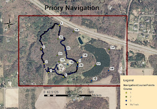
We then created maps for our own path, our group paths, and
a map for the entire classes paths. Each map is provided in the results
section.
Results:
 |
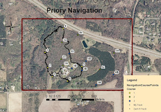
| Figure 2: A map of the overall course and the path that my group took (Zach R. and Myself) according to our GPS units. |
 |
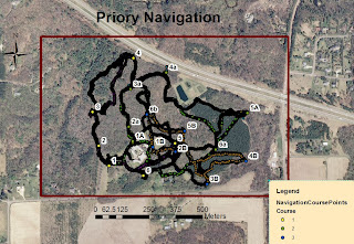
| Figure 3: Map of the overall course and the paths that each member of the class took. You can slightly make out the difference courses by tracing individual paths through the points. |
Conclusion:
This exercise made for an interesting experience. It was somewhat
difficult to navigate with ONLY using UTM coordinates. It involved a lot of
walking and then checking the GPS, then walking more, checking it again,
walking more, and checking again etc etc. It was also made difficult because of
the fact that we still had knee deep snow at the priory. This made it difficult
to watch the GPS while we walked so it turned into guess and check. It also
slowed down our movement quite a bit. Had there been no snow we could have
finished in probably half the time. The one area in which the snow aided was
the fact that it made spotting the point flags pretty easy.
More importantly though, viewing the GPS tracks was
interesting because it showed us just what type of path we took, in relation to
the path we SHOULD have been taking. It also allowed us to track the
differences in our groups track logs. Where we all took very similar routes,
our GPS logs did not always look the same. The same is viewable with other
groups as well.
Overall a good learning experience as I’ve had limited
exposure to UTM coordinate navigation, and the use of the tracklogs made it
pretty interesting to examine post-navigation.

No comments:
Post a Comment